Solo Hiking and Lessons about Life: The Copland Track
A strange thing about traveling alone is that there is no one to disappoint except for yourself.
No one else has a list of things for me to do. There is no one telling me how to do my holiday. No expectations I have to live up to. Except my own.
And even then, there is nothing I must do in New Zealand.
Yet, even when there is nothing that ought to matter, no pressure to do something, the fear of disappointing myself is stronger than I ever would have imagined. When everyone else’s expectations and pressures dropped away, I realized how strong my own expectations are. How strong they always have been, camouflaged beneath others.
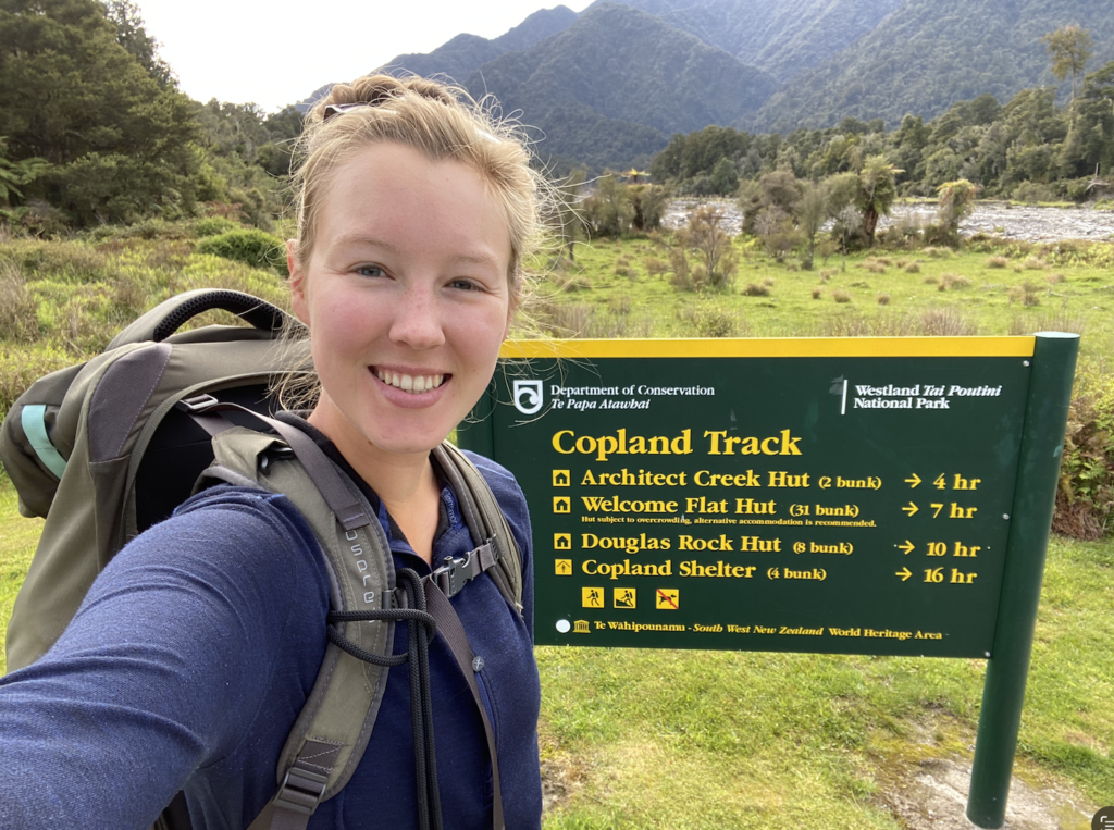
So when I got the idea, months ago, to do the Copland Track on the west coast, I feared this might be a notion that would lead directly to disappointment. Not because the trail would disappoint. But because I was afraid. The DOC website does a very good job of putting the fear of God into hikers regarding the rivers.
To explain: the west coast of New Zealand gets a lot of rain, often very heavy rain. This swells the rivers, making them impassable. The Copland Track has many such rivers—small and harmless most of the time, but capable of growing into deep, rushing rivers that are very dangerous to cross. In fact, river crossings are the second highest cause of hiker deaths in New Zealand.
The warning video for the Copland Track reiterates this danger, as well as rock fall danger. As a solo hiker, the river crossing piece worries me more than it usually would. Doing anything alone in the back country is far more nerve-racking than when accompanied by others.
So far, I’ve done 2 overnight hut hikes. I’ve hiked the Pinnacles, which is an extremely popular overnight hike and day hike, so I knew that at a minimum there would be 79 other people walking up the track. There is security in knowing that if something happened to me, others would be passing by on the same track. I’ve also hiked to Heaphy Hut, which was on a straight, flat path and it was during perfect weather.
But, the Copland Track worried me. I have proper respect for rivers, and for how quickly they can rise, how impossible they can be to cross.
My second worry was regarding hot food. Pinnacles Hut and Heaphy Hut provided gas cookers, but Welcome Flat Hut at the end of the Copland Track does not. I don’t have a backpacking stove, which meant that I wouldn’t have hot food or water. As someone who gets really sweaty when hiking, I always get really chilled when I’m done with a hike and start to cool down. It’s invaluable to be able to drink hot water or eat hot food to warm up. However, I thought Welcome Flat Hut could be an exception. After all, the forecast predicated a low of 7 degrees Celsius. And, the real reason I wasn’t greatly concerned: Welcome Flat Hut happens to be a three minute walk from natural hot pools. So I knew I could at least warm my outsides!
These hot pools are exactly the draw to Welcome Flat Hut. The calling card. The reason I (and most people) want to do the eleven mile hike into the backcountry. The reason, I knew, that I ached so badly to go and the major weight behind my fear that I wouldn’t do it. Because it would be so cool!
The disappointment I anticipated feeling at not doing this hike was immense. Even though no one else cares. Even though I didn’t come to New Zealand with the intention of doing any hut hikes. Even though so many people visit New Zealand and never do a hut hike! Even though it would be perfectly reasonable to just say it didn’t work out or I didn’t have time or I decided not to do it. Still, that fear of disappointing myself loomed large.
So when I opted to visit the west coast during a week of forecasted rain, I knew ahead of time that I wasn’t going to hike the Copland Track. I’d just have to come back and do Welcome Flat Hut in January or maybe in March before I leave. I have so much time, surely I’ll find my way back…
Except that the Copland Track is a three hour drive from Wanaka and I would have already done everything else I wanted to do on the west coast…
What were the chances, really, that I made it back? But I didn’t want to think like that.
So I drove to the Fox Glacier Township and passed the sign for the Copland Track on the drive. Even the entrance loomed large and forbidding. It had a black gate. Somehow the presence of it—the precarious danger and risk involved in the track—grew more immense. And at the same time, my anticipated disappointment in myself grew. Why? I don’t know. I didn’t even know about this hike before I came to New Zealand. I read about it on the DOC website two months ago and a Kiwi recommended it to me a few weeks back, but even he hadn’t done it—only heard good things.
The problem, I repeat, is that I was afraid. And because I was afraid, the disappointment was bigger. I didn’t want to not do something because of fear. More importantly, I didn’t want to not do something because of a fear that wouldn’t exist if I weren’t alone.
That—being held back simply because of solitude—is something that cuts much deeper than just the surface fear of missing out on a cool hike.
Because I want to be enough on my own.
But, I’m not reckless. At the hostel in Fox Glacier, I asked the owner about the track, about the state of the rivers. I also went to talk to DOC, driving an hour round trip to ask about the weather, to inquire about the necessity of hiring a PLB (personal locator beacon to signal emergency rescue services). And, I decided, I was going to hike the Copland Track because the rivers were low, there would be about ten other people including a few DOC rangers on the track, there was a warden in residence at the hut, and there wasn’t any forecasted rain until the end of the week.
If the question was now or never, I was going to do it now. If the question was disappointment or well-researched-and-prepared-as-I-can-be risk, I was going to take the risk. Suddenly, all that fear of God stuff seemed like overkill. I could totally do this. (I firmly believe that knowledge is power, or in this case, knowledge is confidence).
So, less than 24 hours before I needed to have boots on the trail, I reserved my spot at the hut and made up a pack list and prepped for my adventure.
Now, on the other side of it, even sitting here with numerous sandfly bites burning like mini-hell fires in all the hard to reach places on my back and tender-skinned areas of my ankles, I am so incredibly grateful and proud of myself for doing this hike.
It wasn’t easy. I wasn’t always confident. God tested my mettle just a bit, but I did it. And I did it alone; I didn’t let my solitude hold me back.
Follow Me on the Copland Track
(Through this blog, I never hike alone in spirit, even if I am alone logistically!)
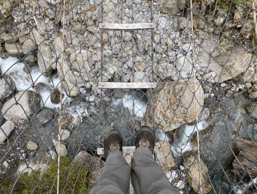
The Copland Track starts with bluster. Less than 50 yards from the carpark is the biggest river crossing: Rough Creek. According to river crossing safety, it’s not recommended to take off your shoes to cross a river, but the hostel owner in Fox told me I should take off my shoes so I didn’t have to hike the next eleven miles with squelching shoes. It’s also best to cross a river at the widest point. It means you spend more time with your feet in chilly water, but the water is generally slower and less forceful as it’s power is spread thin. So I searched for the widest area, where the water ran no faster than walking pace, and charted a course through the rocks. My first deep water solo river crossing!
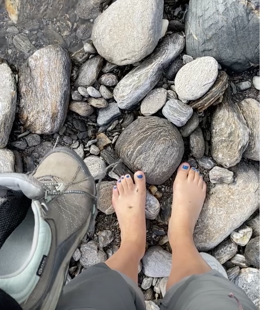
The rocks in the stream bed were, thankfully, not slippery at all and I had no problem picking my way across. However, by the last few steps my feet were aching with the chill. It is snow-melt season and the water carried those snowy memories!
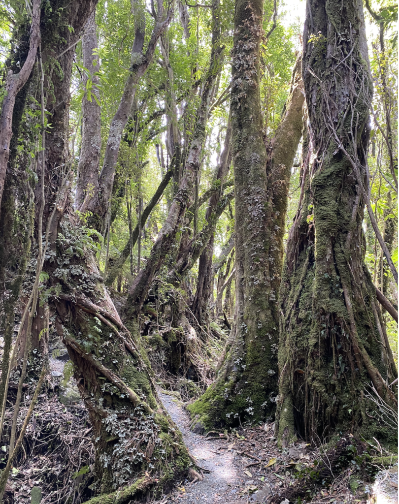
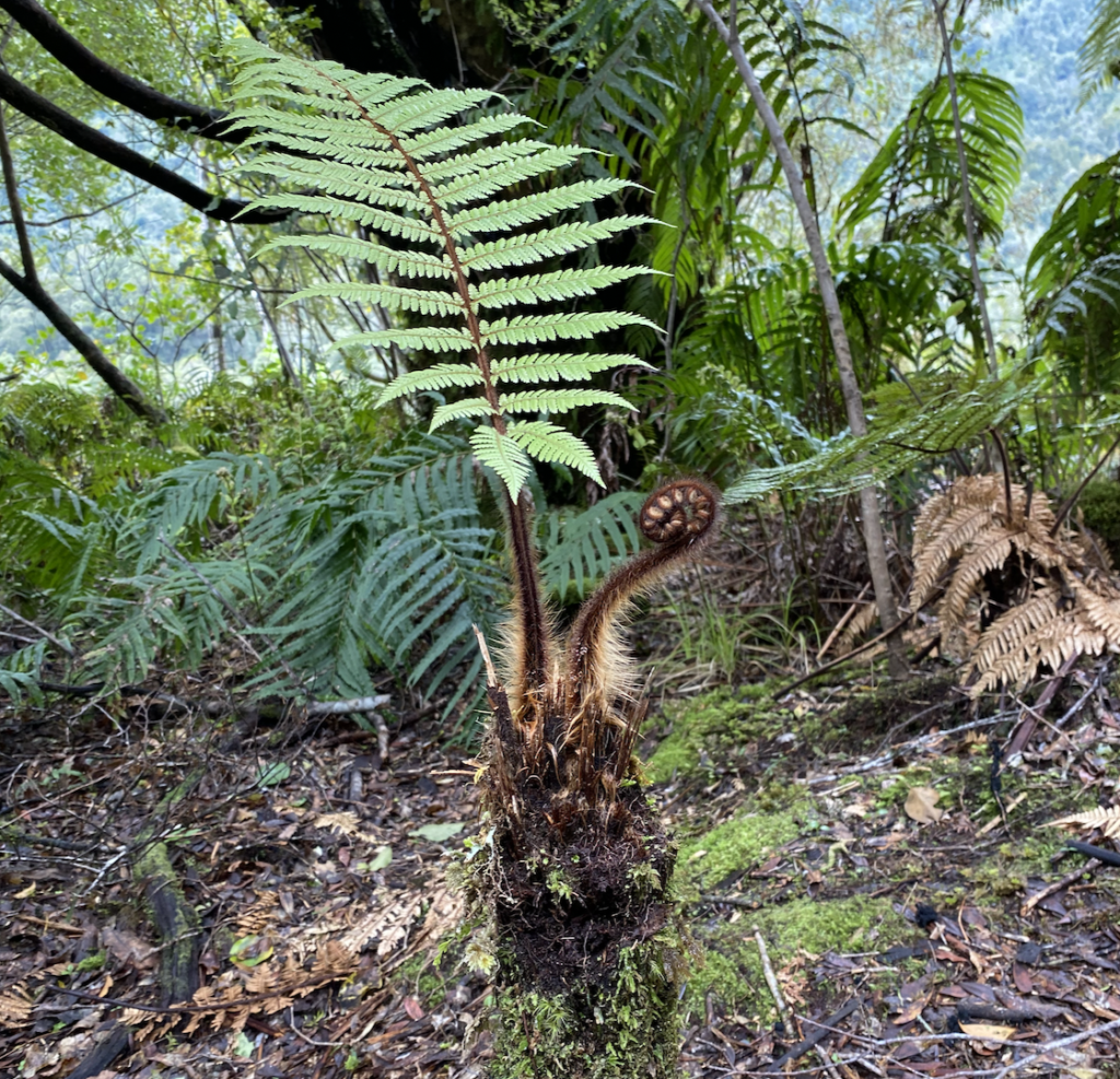
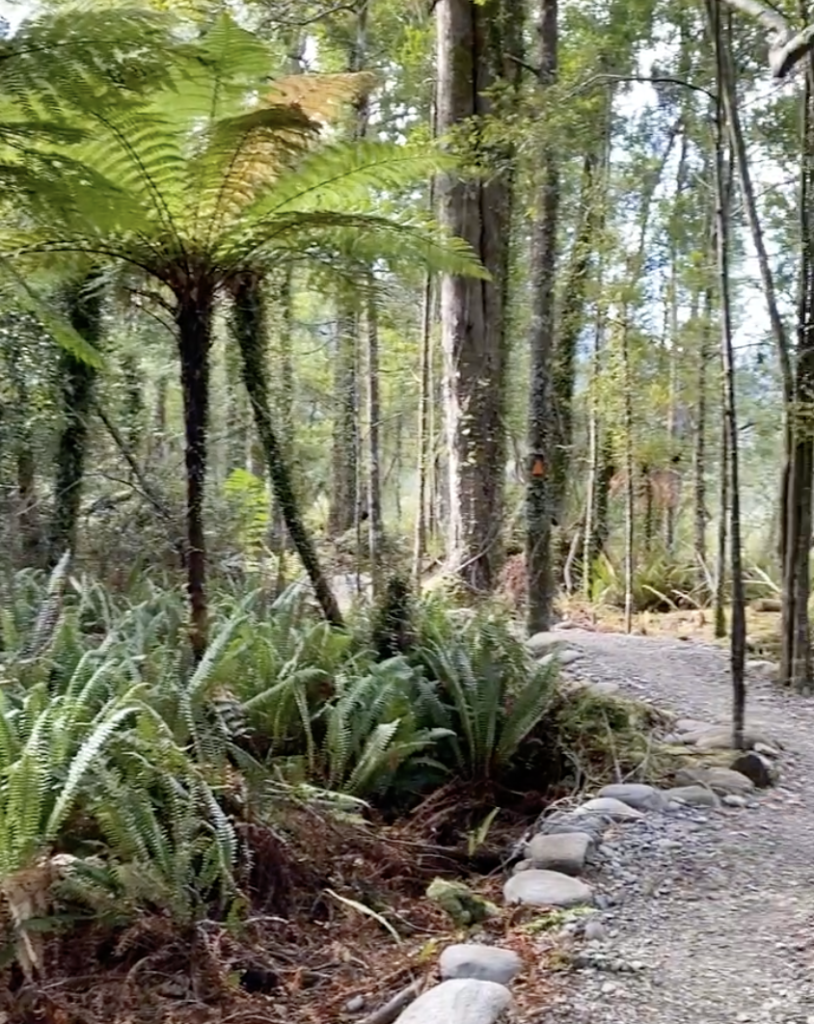
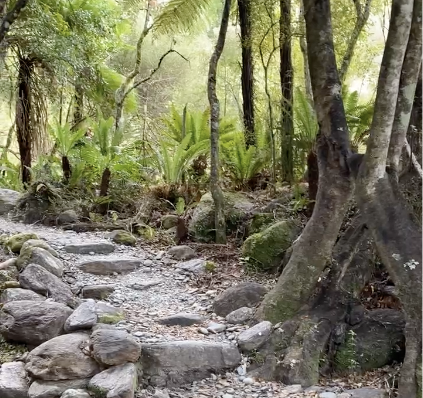
I put my shoes back on and plunged into the bush. The west coast is temperate rainforest region, which means a canopy of puffy rata and matai and totara and kahikitea trees (very similar to my adventures in the Oparara Basin near Karamea). If you’ve never seen any of these trees (or you’re like me and names don’t do a good job of conjuring images), then let me explain in differently. The west coast of New Zealand boasts thick, damp forests of twisting trees, knotty vines, squishy moss, swollen liverworts, and bright, cascading ferns. The earth is dark and damp. It smells like rain even when it hasn’t been raining and everything feels like it’s actively growing at this very moment. Unlike Colorado forests where the main vector of motion is vertical with pines and aspens and dry grasses, the vector here is more like starbursts with the fronds of ferns boisterously defying gravity in every direction. Massive tree roots spiderweb across the ground in all directions like they’re alive, merely waiting for a dark witch to whisper a word and they’ll scurry across the ground using their roots like tentacles as if in a horror movie.
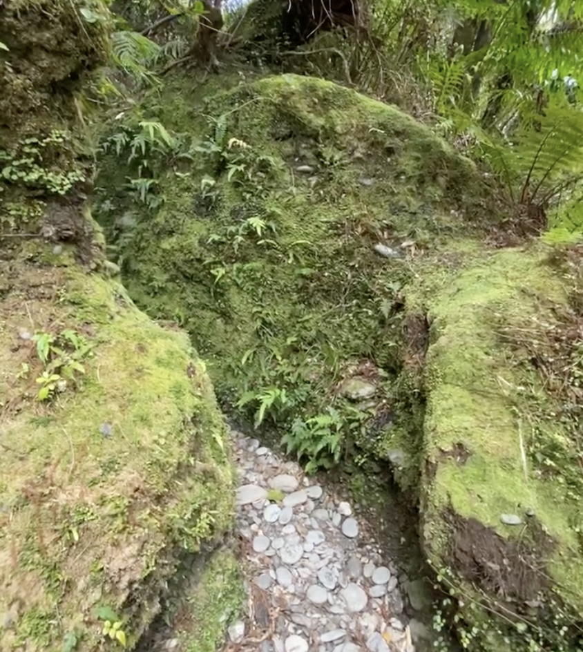
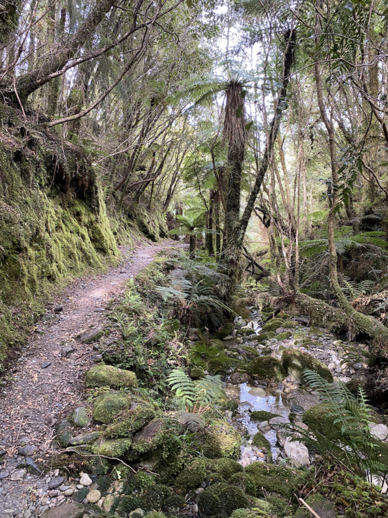
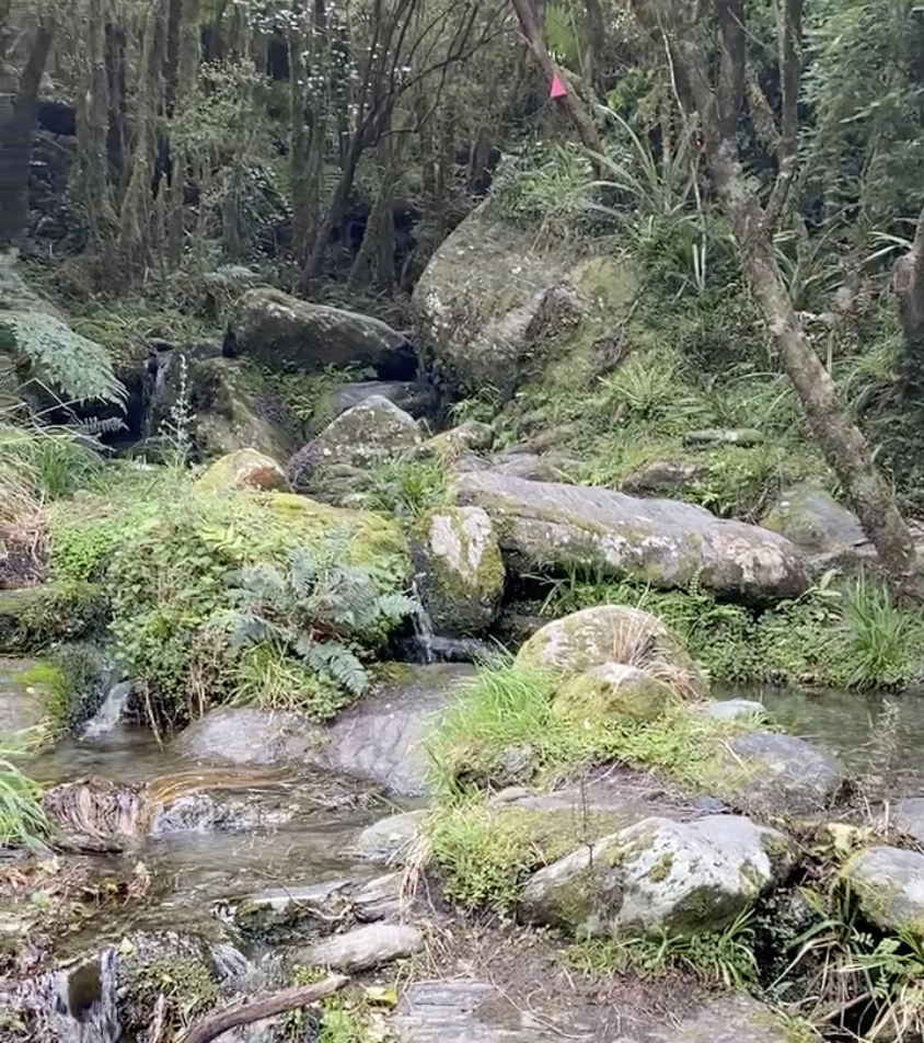
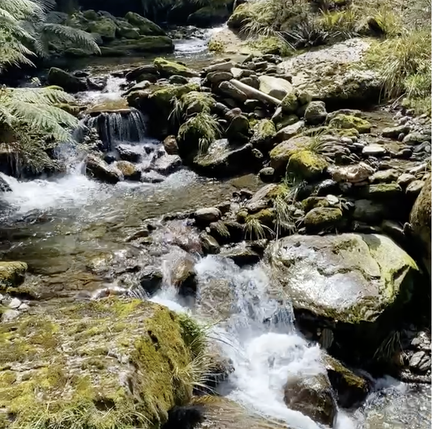
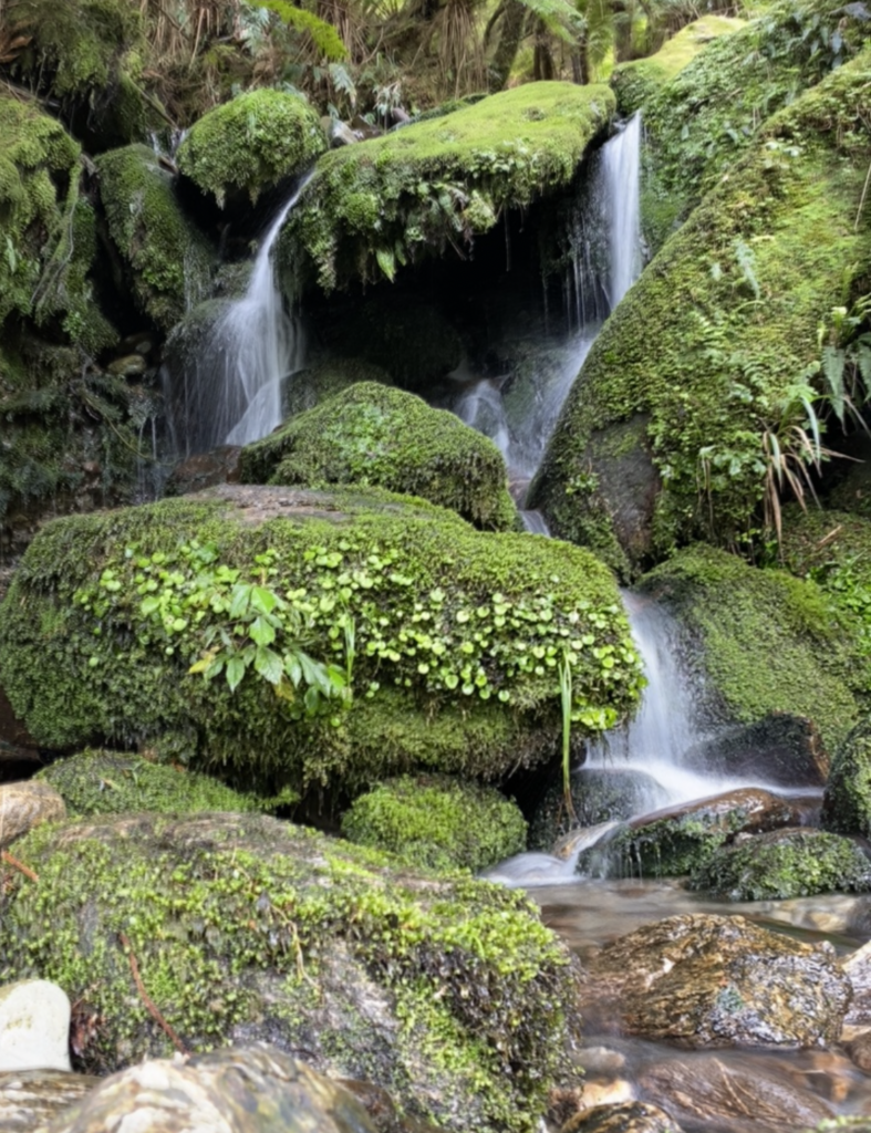
Small streams cross the hiking path every few hundred feet, sometimes little more than a gentle flowing puddle and other times mini waterfalls cascade down loamy banks in imitation of the melt-water waterfalls dropping from the distant cliffs. Sometimes I can easily step over the stream, other times I hop from stone to stone several times to cross the tinkling creek. A few more times I have to remove my shoes and wade through, though these streams are far smaller and less forceful than Rough Creek.
About an hour and a half into the hike, I reach a spot where the trail descends to a small river as it has twenty times already. However, I can see that the river slashes through the path at a diagonal, but the place where the trail should logically continue on the other side is also full of water and river stones. Several times already the trail has merged with a river and I find myself walking through several inches of water for a couple hundred yards. So I’m not sure which river-path to take–slight uphill or slight downhill. I look for an orange triangle marker, but there isn’t one present on either path for a hundred paces. I look for footprints, but see some going both directions, so I’m not the first to have been confused by this junction.
Thankfully, I’m prepared. Several weeks ago a Kiwi told me about NZTopo50, which is an offline and GPS app that has all the DOC tracks on it. So, even though I don’t have any service, I open up the app and select the GPS button. In moments, the map zooms into my location, indicating my position with a purple dot and showing the Copland Track as a slightly wavery blue line. From that, I can see the track heads slightly to the left, so I take the uphill route. After about ten minutes, I finally see an orange marker and the anxiety in my chest settles.
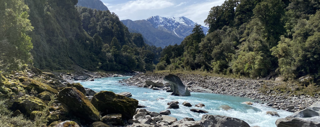
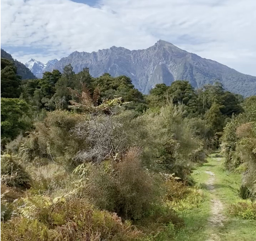
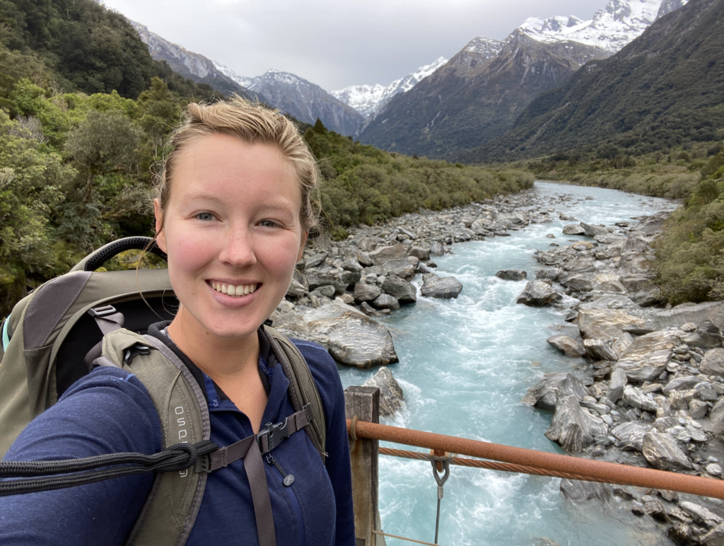
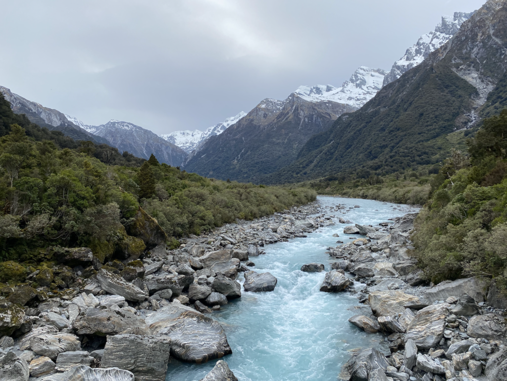
For the first few miles, the track follows the Karangarua River. Though the river is only twenty or thirty yards away, the bush is so thick that I rarely catch sight of it. Sometimes I see a small sliver of pale blue through the tree-fern fronds, but it’s just a teasing glimpse of the glacier-melt river. Just as the river remains elusive, so do the mountains around me. The canopy is thick and only every once in a while does the path open up and allow glimpses of the dark grey and rocky peaks in the distance. The deeper into the valley I go, the more those peaks start to sport patches of snow. It’s really beautiful though also creates a strange disconnect: I’m walking in a humid rain forest in my tank top and wiping sweat from my forehead while snowy peaks crowd around.
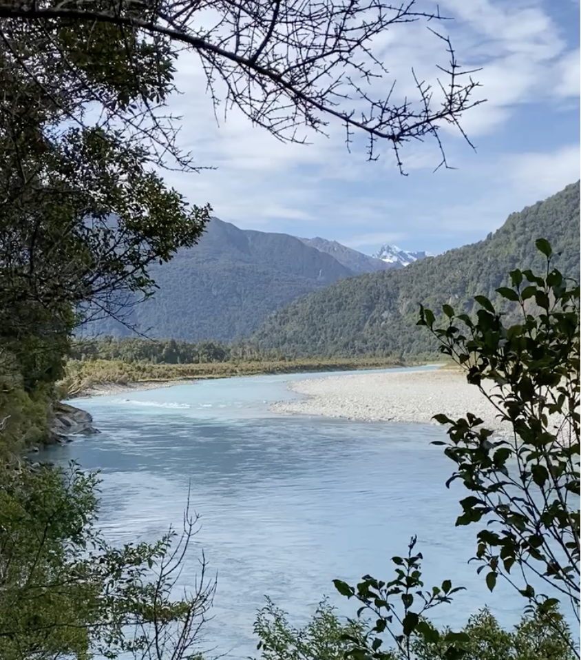
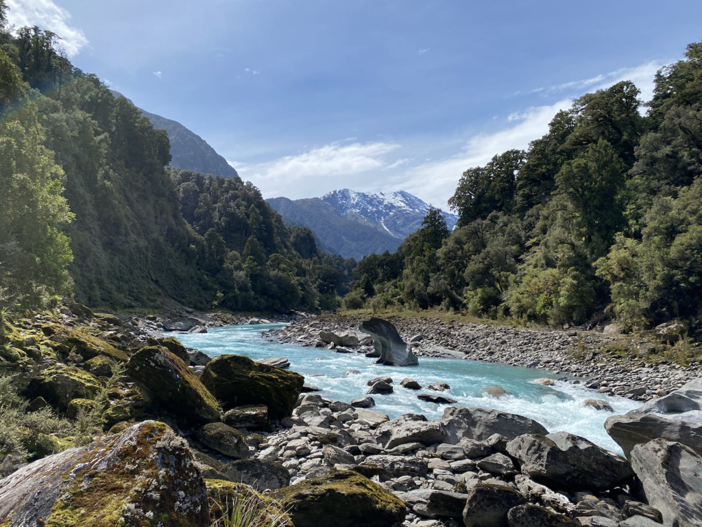
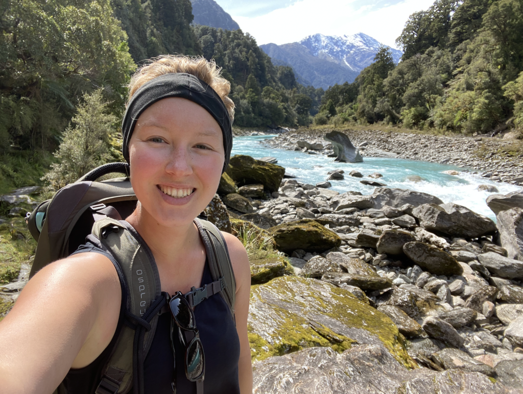
Where the Copland River meets the Karangarua River, the Copland Track turns and begins to follow the bank of the Copland River instead. For a while, I leave the thick forest and pick my way along the rocks of the river bank among stunning scenery. This section takes me twice as long as it should because I am in awe–stopping to take a million pictures, tipping my head back to gap at the snowy mountains and the blue water, jaw dropping as each step reveals a new and beautiful angle.
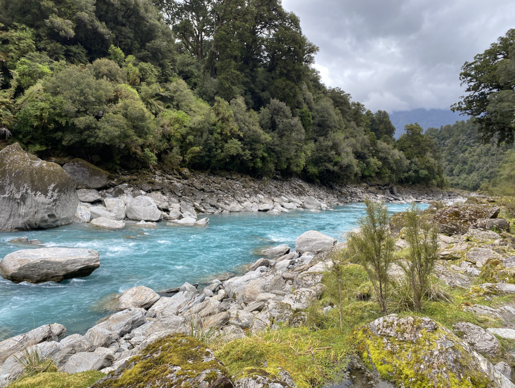
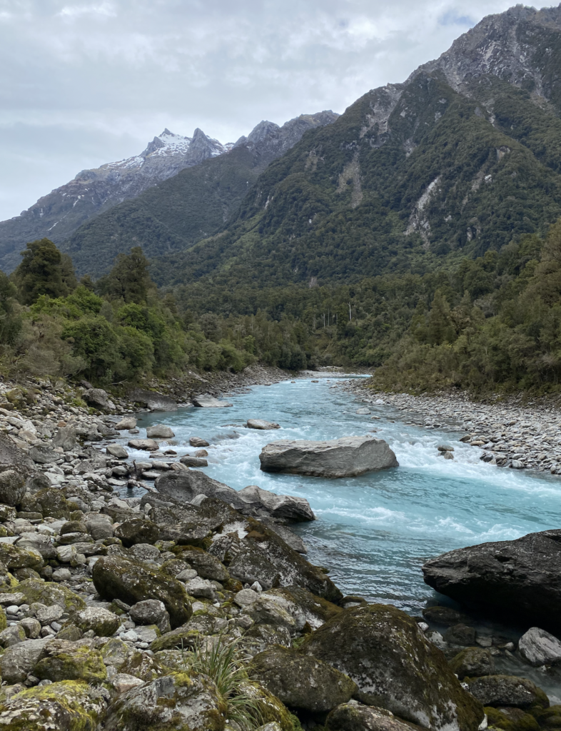
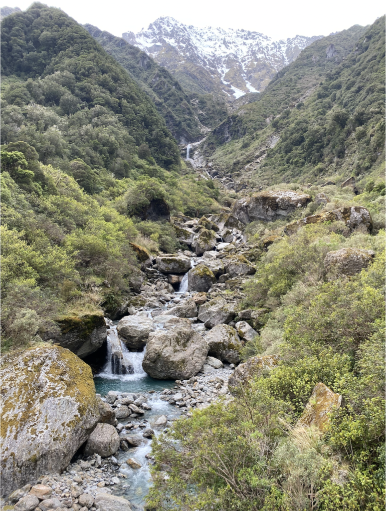
The Copland River is also a glacier-melt river so it’s a stunning Gatorade blue. The color is due to a tiny sediment called glacier flour. Glaciers move a lot and in the process grind up rocks into really fine particles. As the glacial ice melts, the sediment gets caught in the water. Closest to the glacier, the water is generally cloudy and grey because of the high amount of sediment, but as it starts to settle a bit more, the water takes on an unreal blue shade.
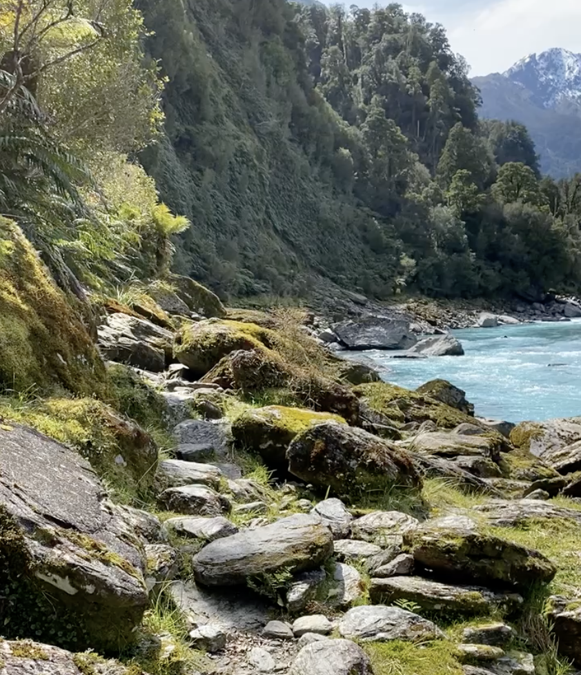
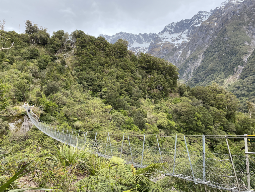
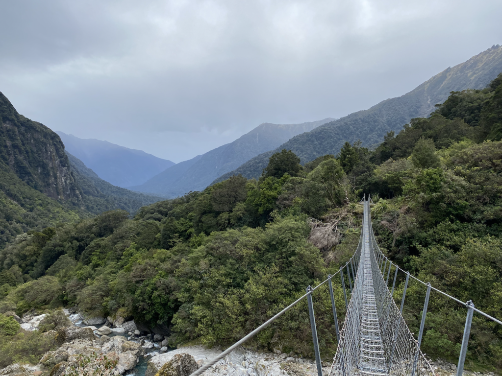
At this point, some of the side rivers also began to grow in size. Unlike Rough Creek which was a flat, slow, wide river bed, these rivers come tumbling down the steep and rocky slope with spitting waterfalls and rushing white water. Thankfully, these rivers are bridged. Sometimes simple wooden bridges stretching from one massive boulder to another, but sometimes they sport the ubiquitous New Zealand swing bridge. As the track has wandered back into the forest, these bridges are welcome both for the beautiful rivers they cross but also for the opening up of the sky and the possibility to take in the vistas.
The track has also grown much rougher and left behind any hint of flat, easy grade. Now I’m climbing up and down the natural rises and falls of the side of a mountain. In several places signs warn hikers not to stop because of rock-fall danger.
It’s been a long day, most of it on uneven terrain. The DOC website estimates 7 hours to reach Welcome Flat Hut, though I generally find I’m faster than most DOC estimates. Still, the track is draining. It looks fairly flat on the map since the path rarely strays far from the river, but when I look later, there was actually 1,600 feet of elevation gain. So I’m understandably weary.
To confuse matters, the DOC website provides a short description of the hike and near the end it says something about crossing one last swing bridge and then arriving at the hut. But there are several swing bridges so every time I cross one I wonder if it’s the last.
Then I reach an impressive swing bridge. It’s a single person bridge made of cable and wire rather than cable and wood planks, and it’s the highest, longest swing bridge I’ve encountered in New Zealand thus far. Far below, the river leaps and roars, cascading in steep waterfalls over massive boulders. I love it.
This, I think. This must be the last swing bridge.
And I’m right. About ten minutes later, I descend to the hut.
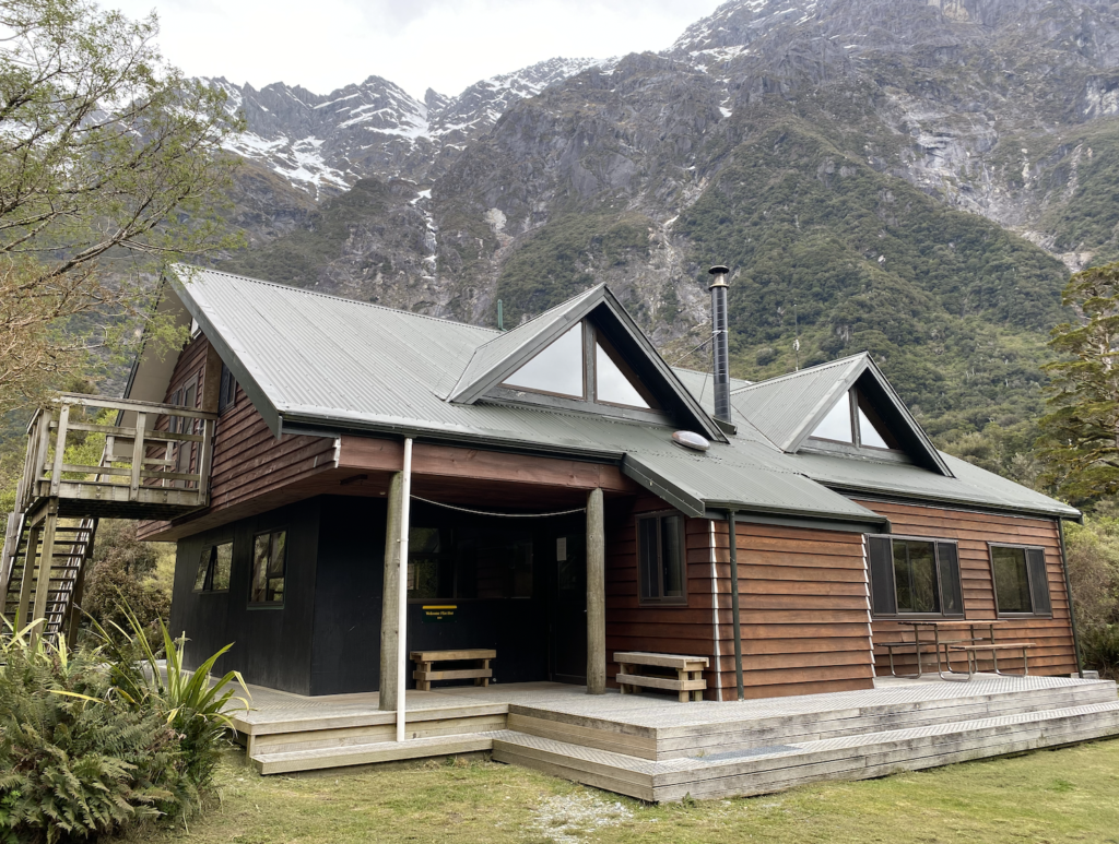
Welcome Flat Hut
The DOC website always has a small thumbnail photo of the huts, but they never do them justice. Based on the DOC photo, I was expecting something small and rectangular, a bit more like the Heaphy Hut. Instead, this hut looks like a proper mountain cabin with a vaulted loft and wide windows. The bunk rooms are upstairs and the downstairs provides plenty of tables and room to spread out. The detached toilets are flush-toilets. Even the Pinnacles Hut didn’t have flush toilets.
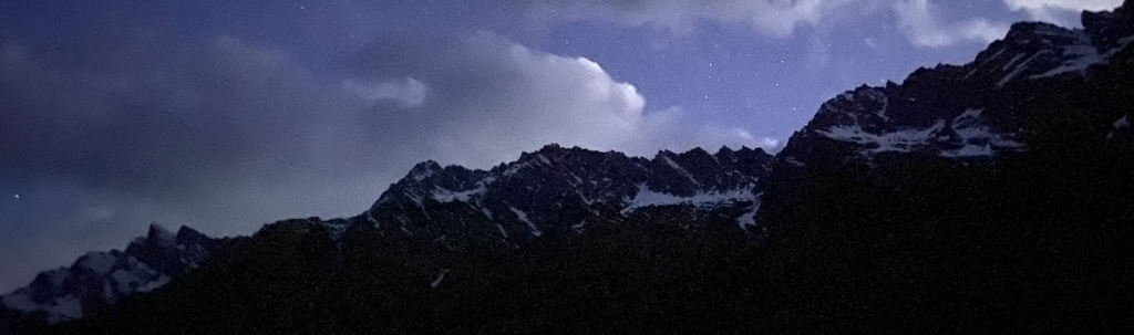
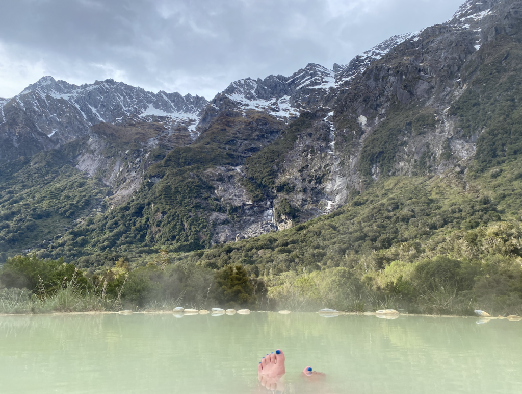
But the most impressive part, of course, is the view. The snow-spotted Sierra Range looms over Welcome Flat Hut like it’s cradling it.
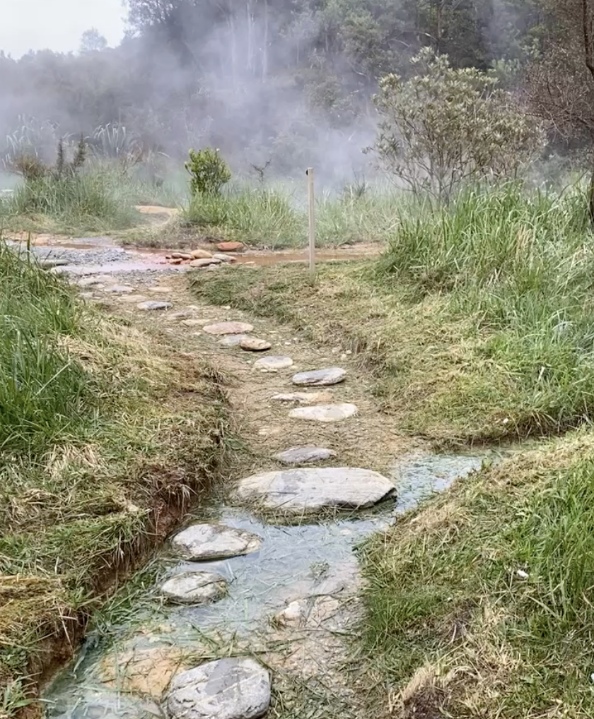
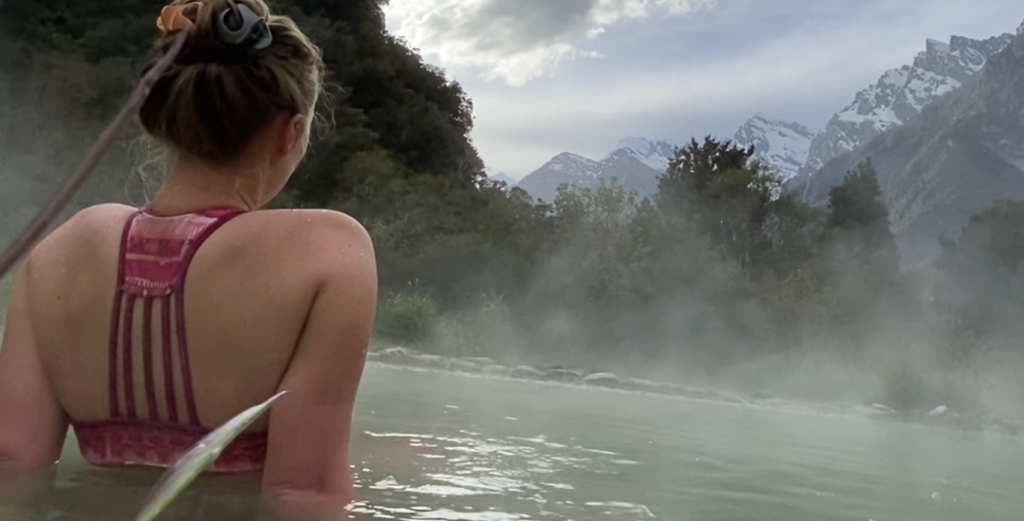
Welcome Flat Hot Pools
I drop my bag on a mattress, pull out my swimsuit, and am hiking to the hot pools within five minutes of arriving. They, after all, are the main reason I’ve made this trek. The draw to head deep into the forest and the mountains away from civilization.
Like the hut, DOC has a photo of the pools as the image for the Copland Track, but it hardly does it justice. I was imaging a single pool, perhaps ten feet in diameter, where I’d be crowded in with all the other hikers as they began to trickle in.
Oh no.
The Welcome Flat Hot Pools far exceeded expectations. A human-placed stone path leads to a steaming stream (supposedly about 130 degrees) that meanders out of the bush. It’s reddish-orange with hot water loving bacteria. The stream disburses into three different pools lined with soft whitish mud. The edges are lined with rocks to provide a place to set water bottles or to rest your head. A fourth pool has formed between two others, and this one is the coolest (being the furthest from the hot water source).
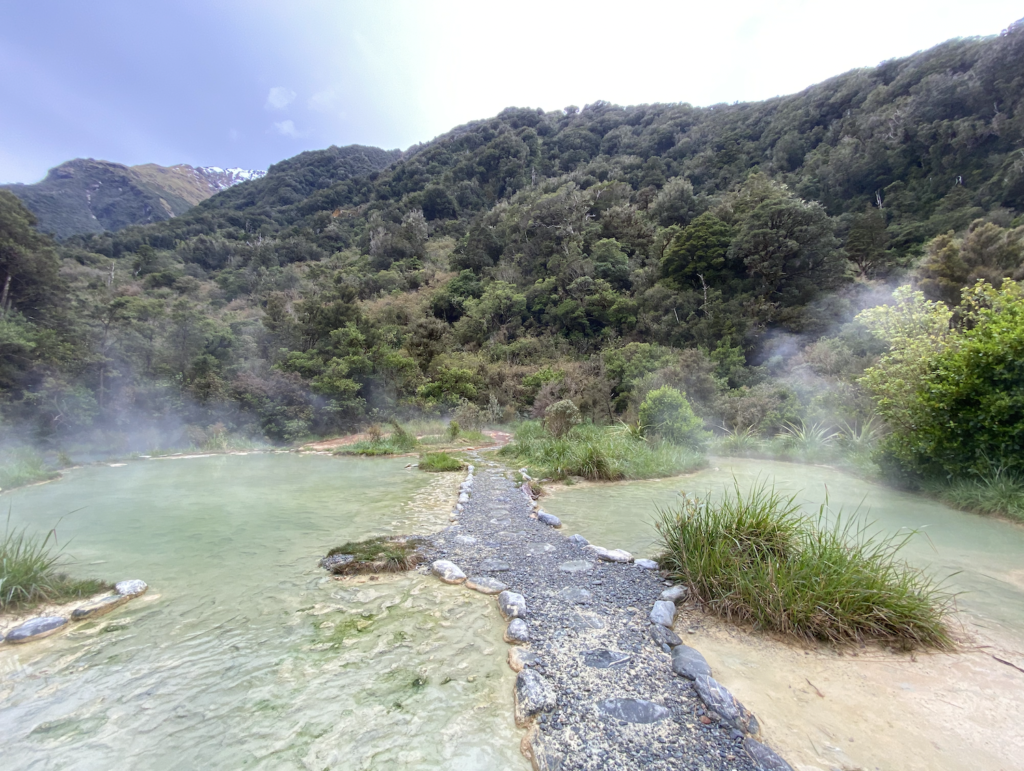
Each pool is twenty to thirty feet in diameter–plenty of space to spread out.
There are two things that would improve the pools: first, they could be a bit deeper. At the deepest, they were about a foot and a half. Second, the eradication of sand flies. This is also a reason why deeper pools would be better! The only way to escape the sand flies is to immerse yourself in the water, laying down with your head on a rock or propped on your hand. Even then, the sandflies buzz around your face and neck, taking vicious bites. I’ve got bites on both ears!
Still, lying back in the pool with my head on a rock and my eyes tipped up toward the snow-capped mountains is magical. When a slight breeze picks up, the sandflies disappear (only temporarily, unfortunately), but for those few minutes, it’s absolute perfection.
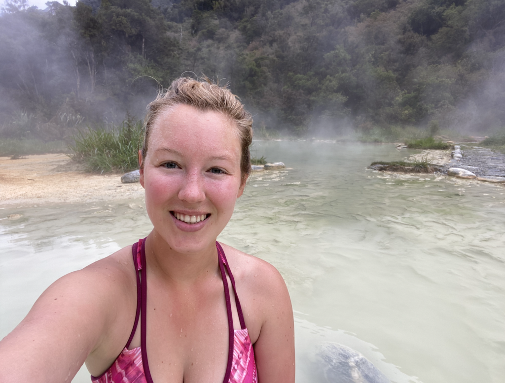
I arrived at the same time as three other hikers, and we all head to the pools. Over the next few hours, more hikers trickle in. Most settle in the fourth and coolest pool, but I hurry (so the sandflies can’t get me) into one of the hotter pools. Somehow I manage to stay there for an hour even as other people come over to try it and leave after only a few minutes. Yet, I’m not quite as impressive as the seventy-year-old hut warden who walks up in his flowery speedo and sinks into the hottest pool–the one that has boiling water on one end!
Around 6:00, dark clouds loom ominously down the valley, so I get out and get dressed, heading back to the hut to read for a while. It’s a good choice as within a half hour most of the others hurry back to the hut as rain drops start to fall. Despite the warmth that seeped into me in the pools, I start to get cold. I don’t know what is going on with Kiwi’s but they do not seem to feel the cold. I’ve got my socks and sweats and thermal shirt on, and many of them are walking around barefoot and in shorts. Of course, everyone else has a gas cooker and is eating warm food and drinking tea.
I eat an admittedly delicious, but room-temp, meal of left over veggie risotto with slices of summer sausage, and pull on my wool hat. By 9:30, I’m snug in my sleeping bag and there I finally warm up.
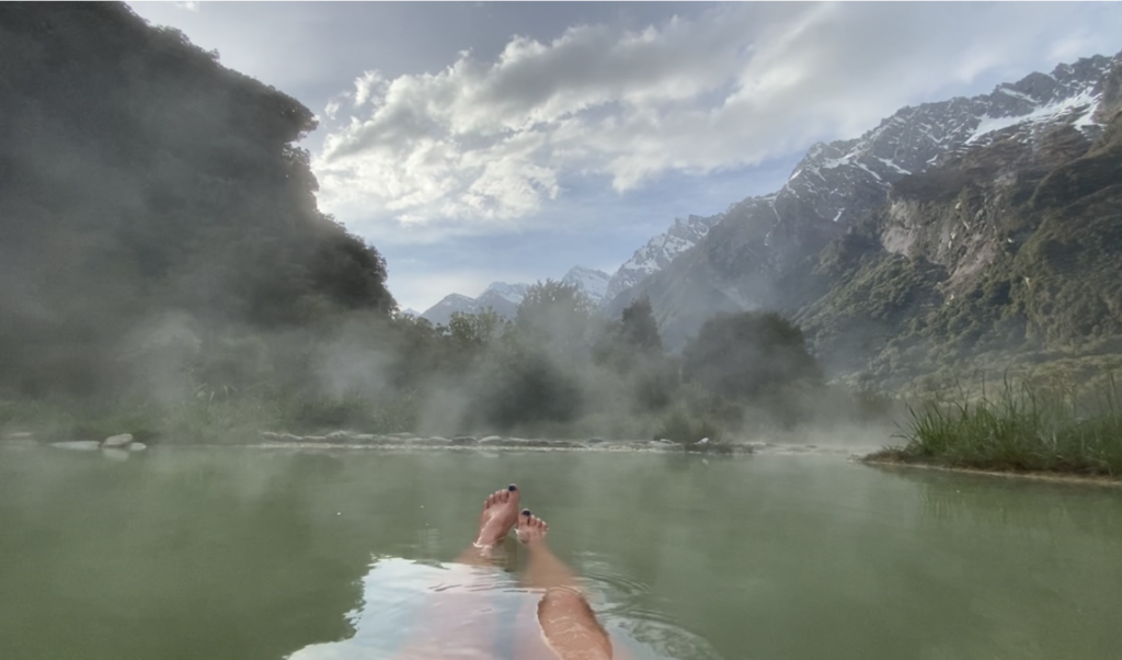
The people around me set their alarms for 6am so they can hop in the pools for sunrise, but I’m quite sure it’s going to be cloudy. So I sleep in and head out to the pools at 7:30. And I have them to myself!
So relaxing, but it also allowed me to take a few photos without feeling self-conscious!
There’s something about sitting in a natural hot pool with the mountains rising high and close around you, the only sound the distant roar of waterfalls as melt-water streams down the steep rock slopes. In that moment, I would have loved to share it with the people I love, but I was equally content to be there by myself with my thoughts.
Hiking Out
Welcome Flat Hut is actually not the end of the track (though it is for most people). Hikers can head another three hours up the valley to Douglas Rock Hut. And expert-level mountaineers can actually continue the climb beyond that through Copland Pass, which spits you out right next to Mount Cook.
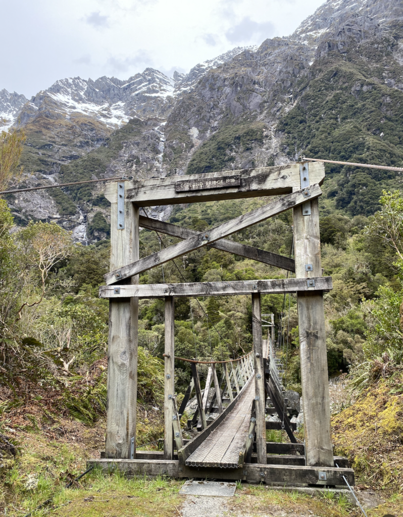
While I was looking at the map the night before, I saw that the track to Douglas Rock Hut passes over the Copland River. I hiked beside the pretty blue river for miles, and though I passed over many bridges, they were all side streams. I wanted to stand over the Copland River.
So, at 9:30 my backpack is packed and I’m ready for the long hike out. In a stroke of luck, my hostel for that evening has a hot tub, so I’ll be rewarded with a hot soak (though subpar views) at the end of this long trek, as well. But first, a quick detour. I follow the track to Douglas Rock Hut for several minutes, reaching the Copland Bridge. And I am so glad I took this detour. The bridge itself was beautiful, built in 1918. And the views…
Easily my favorite views of the whole hike.
West Coast, Wet Coast
The day before it took me five and half hours (including a twenty minute break for lunch) to hike to Welcome Flat Hut. The hike out will probably be faster since it’s mostly downhill, but really I’d rather not get back to my car until after 3:00 anyway, so I can get to my hostel around 4:00, can soak in the hot tub, then have dinner and go to bed. So I take it slow, stopping for more pictures, lingering over my lunch…
Then the sky opens up and the rain starts to fall and I’m wishing I was further down the path!
When I last had cell service (so in the parking lot the day before), Thursday’s forecast was cloudy but no rain. But it is the west coast and I guess that changed overnight. It starts slow and I’m picking my way over the rocky banks of the Copland, going extra slow because the wet rocks are slippery. Walking in the forest is slightly better as the canopy slows the rain, but then it gets saturated and instead the drips from above are just as numerous as the rain drops. I just embrace it. The rain does make the forest come alive–brighter colors, larger mosses and liverworts–swollen with the water.
In the back of my mind, I’m thinking about Rough Creek and my river crossing. There is an emergency bridge on Rough Creek about an hour’s walk upstream, so it would add two rain-drenched hours to my hike, but if the river is swollen and rushing, living another day is worth the extra miles.
As I’m walking, my legs on turbo boosters to get out of the rain, I am noting each side creek I pass and trying to decide if it’s running higher than the day before. I don’t think so, so probably Rough Creek is fine. But the anxiety of it is a low-level hum in the back of my mind. I’m new to this, and my lack of knowledge weighs heavy.
I’ve got a rain coat, but my pants and shoes are soaked, so I don’t bother taking off my shoes for the short river crossings. Somehow the beginning of the track feels one hundred times longer than it did going in. Must be the chilly-rain-effect. I am reassured, however, by the presence of several DOC rangers doing some trail maintenance. They keep working with their weed-wackers and chain saws even in the pouring rain and I figure that if they thought Rough Creek was going to be impassable that they would have left already.
After two hours, I finally reach Rough Creek. I can see my car. The river looks no higher than the day before. I don’t see any debris or leaves in the water (which a local told me was a sign of heavy rain upstream). So I head across the river, retracing my route from the day before. It’s a relief when I reach my car. I strip off my my soaked pants right there in the middle of the lot, dump water out of my shoes, and crawl into the car. Thankfully, I’m traveling with everything I own, so I have a towel to dry off. I crawl into the back seat and my shirt comes off too and I run the towel over my soaked body.
That’s when I remember how many sandflies flew into my car the day before. I’d just shut the door, hoping they’d all be dead when I came back. Well, I’ve now learned that the life-cycle of sandflies is not shorter than thirty-six hours. So, unfortunately I’m trapped in my car with what seems like fifty sandflies, while a deluge comes down outside. And I’m only wearing my underwear.
I get dressed in dry clothes as quickly as I can, swatting and killing sandflies with a manic intensity. Still, as I put my car into drive and pull out of the parking lot, I feel, along with the itch of sandfly bites and several shivers, a huge feeling of satisfaction. I did it.
There’s a 99% chance that if I hadn’t done it that day, I never would have done it. But I did it. And I did it alone. And I loved it (most of it). My emotions were a tangle of feeling accomplished, confident, proud, giddy, impressed, relieved.
Upon reflection, the fear I felt beforehand was mostly unfounded. It brings to mind a favorite quote:
“Most obstacles melt away when we make up our minds to walk boldly through them.”
The DOC website certainly plays up the river crossing danger. It rained hard for two hours and none of the rivers were affected. Of course, now that I’m writing this after two days of hard rain, I can see that the rivers near Franz Josef Glacier (where I’m staying now) are running fast and high. I wouldn’t cross Rough Creek today. But it takes a while for the rivers to react to the rain.
Additionally, before doing my research, I hadn’t realized there was a full-time warden at the hut, nor how popular the trail was. Both of those things eased my anxiety around this hike. It was long and difficult, but it needn’t have loomed so large and scary in my mind. But that’s the reality when you’re alone–sometimes things take on a life of their own.
The satisfaction of eating a hot dinner that night, of sinking into a warm bed and sleeping long and hard only enhanced the satisfaction I felt at doing this hike. I try not to be stupid and reckless about my safety. But I also try not to let fear hold me back. And, just like in Kaikoura when I was scared of the open ocean but went snorkeling anyway, I am so happy with myself and proud of myself for doing the Copland Track. Truly, happy tears are prickling at my eyes as I write this.
Because I did it. And I came out of it so much stronger.


2 Comments
Uncle Mike
Way to go Maddie!
Great write up! I hope it (NZ) is as impressive as your writings make it sound!
Getting closer everyday. Can’t wait !
Maddie
I am so excited to show it to you. You’re going to love it and we are going to have so much fun!